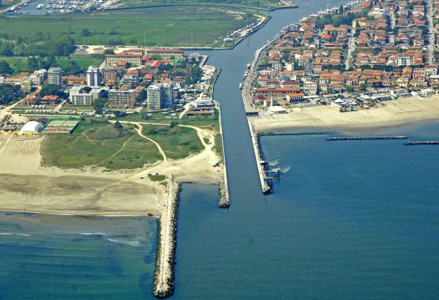
This section provides an example of local coastal governance in the case study area of Porto Garibaldi, Italy.
Governance of coastal zones and disaster risk
Coastal protection and management
Long- and short-term actions within the 2005 regional ICZM plan in relation to beach erosion and sediment shortage/loss are:
- The evaluation of coastal issues through an integrated and holistic perspective;
- Subsidence reduction through a better control of water extraction (from civil and agricultural / livestock consumption) and use especially during the summer season when the coastal population increases significantly
- Actions on rivers to favour the natural bedload sediment transport (dam removal, avoid to take sand out of riverbeds, change of land use);
- Discouraging the utilisation of hard coastal protection structures in favour of soft solutions (e.g. replenishment);
- Favouring the inland relocation of bathing establishments;
- Reducing and/or completely halting the expansion of coastal urban areas;
- Increasing the good practice of reusing dredged sands (from ports and channels) for nourishments (after the certification of absence of pollutants);
- Favouring the good practice of recovering sand from beach cleaning (in the past the sand was brought to waste disposal areas and thus lost).
The Region also issues spatial planning guidelines, that include the classification of important elements of the territory (e.g.: protected ecosystems, etc.). The most important plans are named Piano Territoriale Regionale (PTR) and Piano Territoriale Paesistico Regionale (PTPR). Provinces, following the guidelines and rules of the PTR, have issued the Piano Territoriale di Coordinamento Provinciale (PTCP).
Coastal Municipalities produce the so-called “Piani Spiaggia” (Beach Plans) that regulate the economic activities along the coast. These plans are used to define which activities are allowed along the beach, what parts of the beach can be used for tourist (and thus economic) reasons, etc. The beach of the Municipality of Comacchio where Porto Garibaldi is located, is categorized according to 5 zones (Zone A - equipped beach; Zone B - natural beach; Zone C - sandy shore for special installations; Zone D – public access beach; Zone E – hinterland/surrounding areas). Plans are discussed with the owners of economic activities, and the general public (e.g.: local residents).
Along the Emilia-Romagna coastal area there is a very important common practice identified as the “winter dune” construction that is the creation of sand mounds (artificial dunes) to protect establishments from damages and inundation during the winter season (Harley and Ciavola, 2013), typically by scraping the sand from the lower to the upper beach. In the Porto Garibaldi beach this practice is carried out and inside the beach management plan some areas that at present are not protected by winter dunes (i.e. Lido degli Estensi) have been identified where artificial mounds can be placed. Nevertheless, winter dune construction is a traditional ad hoc measure that has demonstrated to be, in some cases, useful to avoid marine ingression. In 2006, the practice was regulated through non-compulsory guidelines to avoid erosion problems related to the construction of artificial mounds.
Flood risk management
The EU Floods Directive has been implemented at the regional level in order to define the areas that are flood-prone and to evaluate the flooding hazard from rivers and along the coast. The two hazards have been analysed separately. Flood Hazard maps were issued for the whole regional territory and for the coastal area.
River flooding
Emilia-Romagna includes three districts: Padano, northern Apennines and central Apennines.
The Padano district includes the Po river and its tributaries. Because the Po river flows in different regions, the flood risk management plan was issued by several institutions which include the AIPO (Autorità di Bacino del Fiume Po) and Emilia-Romagna, Liguria, Lombardia, Piemonte, Veneto, Valle D’Aosta and Trento (autonomous) regions. The adopted methodologies considered the different aspects of the largest Italian river with many criticalities.
The flood risk management plan for the northern Apennines district divides the territory into three Units of Management (UoM). Almost the whole extension of the district is included inside the regional boundaries. The three units are: UoM of the Reno river, UoM of the Marecchia-Conca rivers; UoM of the Romagnoli rivers. The basins of the Reno, Romagnoli rivers and Marecchia - Conca are located within the northern Apennines district, comprising three regions (Emilia-Romagna, Tuscany and Marche), 11 provinces and about 213 municipalities, 163 of which in the Emilia-Romagna Region, 29 in Tuscany and 21 in the Marche region.
The hazard component for river flooding was evaluated using three different methods:
1. From hydrologic-hydraulic studies carried out with one-dimensional hydraulic models or simplified hydraulic calculations for streams that flow in the most populated areas, in valleys and hilly portions. Then, a comparison was carried out between maximum water levels and land elevations, resulting from topographical surveys or from regional technical maps (CTR) at scale 1: 5000;
2. By geomorphological-hydraulic evaluations for mountain stretches and water courses of lower importance, combined with historical studies of the evolution of rivers over the past 60 years, by means of maps and aerial photos (first reference year 1954, GAI flight);
3. From hydrologic-hydraulic studies carried out with one-dimensional hydraulic models for water courses located in plain areas, mostly dammed, the evaluation of the areas that are more affected by flooding and those reached by the water on the basis of the identification of hydraulic cells and areas bounded by embankments and barriers.
Two return periods were analysed: the <= 50 years (25, 30 or 50) and the <= 200 years (100 or 200). The hazard was defined high (P3) and medium (P2) respectively on the basis of the probability of occurrence of the considered events. More probable equals a higher hazard level. The choice between the different return periods was made on the basis of the historical knowledge of the degree of criticality of the various sections.
An additional low hazard level (named P1) was taken into account, but only for the Po plain area and with a simplified approach: a hydraulic P1 hazard was assigned to cells located nearby the watercourse or to cells adjacent to P2 areas. The probability of flooding for the P2 and P3 return periods was derived from the probability of the designed rainfall used in hydrological models for the evaluation of flood hydrograph.
Several flood-prone areas were identified. These areas have an extension of 827 km2 in the P3 setting (high hazard), of 3450 km2 for P2 (medium hazard) and 4,500 km2 for P1 (low hazard). In the calculation the flooded areas from two different streams were counted twice.
The geological and geomorphological settings of the regional territory, as well as the natural drainage system, the land reclamation works and the climatology were taken into account.
Hazard maps were then translated into risk maps through the evaluation of exposed elements, their value, location and vulnerability. Elements such as agriculture, farms, industries, cultural heritage, the population, etc were taken into account using the large number of information available at the regional level (e.g. land use maps).
Finally, the central Apennines district flood risk management plan was produced through the collaboration between the Autorità di Bacino del Tevere and Emilia-Romagna, Toscana, Umbria, Marche, Abruzzo, Lazio and Molise regions. The Basin authorities of Fiumi Abruzzesi and Fiume Sagro, of the regional basins of Lazio, regional basins of Marche and the Fiume Tronto were also contributors to the plan. The district includes one of the largest and most important rivers of Italy - the Tevere river. Three return periods were evaluated: 500 years (defined as a rare event, low probability of occurrence); 100-200 years (low frequent, medium probability) and 20-50 years (frequent, high probability). The same codes (P1, P2 and P3) used for the northern Apennines district were adopted. The Emilia-Romagna region contributed to the plan only for a small portion of the upper part of the Tevere basin. As stated for the northern Apennines district, all the significant available information were evaluated to produce the hazard and risk maps (geology, geomorphology, historical data, exposed elements, etc).
The coastal area
The regional coastline is almost 130 Km long and is composed of low-sandy beaches. Coastal provinces are (from north to south): Ferrara, Ravenna, Forlì-Cesena and Rimini. For the evaluation of the flooding hazard many important aspects were considered, such as the evolution of the shoreline, geomorphology and geology, including the elevations above Mean Sea Level of the coastal corridor (from 1 to 3 km landward from the shoreline), land use change over time, coastal protection structures, historical storm events and their impact, etc.
The coastline is highly urbanised, especially in the central-southern sectors. Sand dunes had almost disappeared with the only exception represented by short stretches located in the Ravenna and Ferrara provinces. To avoid beach erosion and to lower the impact of storm waves, a large number of protection structures has been built starting from the 1970s. In the last two decades, beach erosion has been counteracted through sand nourishments.
The flooding hazard component for the coastal area was evaluated taking into account three return periods: 10, 100 and > 100 years. The hazard was defined as low (P1, >100 years), medium (P2, 100 years) and high (P3, 10 years). The same considerations for what concerns the terminology described above for river flooding were applied to coastal flooding. The maximum water levels for each return period were computed as the sum of wave set-up, surge and high spring tide (data extracted from the literature, for more details see Perini et al., 2016). The three water levels were then the input for a model built using a GIS software program to carry out a least-path analysis through the Cost Distance Tool of ArcGIS. The methodology is described in detail in the paper by Perini et al. (2016).
The hazard maps were then related to the exposed elements, through the same methodology applied for river flooding, to produce risk maps. Therefore, the location, characteristics and value of the receptors were evaluated using different sources of information and the large number of data available at the regional level. An important element that characterises the coastal area is the presence of tourist facilities. They are represented by permanent structures (concessions) located on the rear part of the beach and that provide a large number of services to tourists in the summer season, such as renting of sun-chairs and umbrellas, restaurants and bars, changing cabins, playgrounds, etc. Because the concessions are located on the beach they are the most exposed receptors.
The hazard maps showed that the coastal area is exposed to marine flooding especially in the central and southern portions (Ravenna and Forlì-Cesena provinces). The low-lying nature of the coastal area, destruction of dunes and the shortage of natural sediments are the main causes for the increased vulnerability of beaches and urban areas. Furthermore, the increased urbanisation and beach occupation by man-made structures increased the exposure of the population and assets to flooding.
Civil protection and disaster risk reduction
Disaster risk reduction in Italy is chiefly carried out at the regional and municipal levels. Regional civil protection agencies are responsible for coordinating operational activities on the ground. This is done with the assistance of Municipal Operating Centres, which are formed by representatives of governments, organizations and the Operating Structures. Resources and national preparedness are organised at the national level by the Civil Protection Department, Presidency of the Council of Ministers. Law 225/92 is the fundamental framework regulating civil protection at national and local levels.
The Italian territory is divided up into 134 alert zones. Following a warning of adverse weather conditions, regional Authorities declare the level of criticality for each alert zone. The case study area of Porto Garibaldi is included in the Alert Zone EMIL-D Three levels of alert are issued from the Regional Civil Protection Office to administrators and the population: ALERT YELLOW (the lower), ALERT ORANGE and ALERT RED (the higher).
In the Porto Garibaldi area, a range of DRR measures (e.g. canal dredging, beach nourishment, elevation of dikes, renovation of drains, protection of coastal dunes) are carried out regularly. Their aim is to protect tourist activities, inhabitants and infrastructure as well as to save natural assets such as salt marshes and dunes, and the water quality of the inland Comacchio lagoon.
However, these activities are not well integrated and local actors and institutions do not take shared actions. Most of the time, decisions are made at different levels following different approaches, without an integrated strategy. Dissemination and exchange activities to the general public and among institutions are well structured but these activities are not translated into shared practices.
Engagement of non-state actors in coastal governance
The Porto Garibaldi case study site comprises different actors, from the regional, provincial and municipality level, to economic sectors and the natural park administration. Economic activities are represented by the owners of the concessions (bathing establishments located on the rear part of the beach), hotels and restaurants. Lido degli Estensi and Spina comprises a large number of second homes. Eco-tourism is also important, such as biking, walking, bird-watching and boat trips in the lagoon and in the Porto Garibaldi navigation channel. Lido degli Estensi is also the location of a marina. Other economic activities are related to fishery and fish farming (especially eels). Shell-fish farming is also an important activity. The southern part of the natural area, close to the Reno River mouth, comprises a military training area.
Finally in the same area there are large parts of land belonging to a single owner (Orsi-Mangelli), which is informally involved in consultations when coastal works take place in the area surrounding the Reno river mouth. Likewise the Italian army is involved in management of the area and in the past has directly supported coastal works.
In the inner part of the Bellocchio nature reserve, along the Comacchio lagoon, there are gas extraction activities by the ENI oil company. They are involved together with other public stakeholders (Comacchio municipality, Emilia-Romagna Region, Po National Park) in a working group that monitors the impact of these activities on the natural and built environment. In the past, ENI has supported this working group by specific research data collection undertaken by independent experts.
The only associations present in the area are those of the fishermen and commercial beach operators. The latter have a strong lobbying capacity, which in the past has justified ad-hoc coastal protection structures and sand shifting in the area south of Lido di Spina (cf. Nordstrom et al., 2015).
Stakeholder perceptions of governance
The graphic below provides a snapshot of how governance in Porto Garibaldi is perceived by those living and working in the area. The responses are the result of in-depth interviews conducted with 8 coastal stakeholders from five stakeholder groups (SH2,3,4,5,8) presented in the list on the right. Interviewees who commented on the mode of governance are plotted on the graph on the left.As these interviews come from a reduced number of interviewees they are not necessarily representative, but provide a snapshot of local opinion.
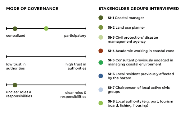
Coastal governance in Porto Garibaldi is affected by many of the general issues of governance discussed in the general overview of governance in Italy as well as in the Bocca di Magra case study. Regional, provincial and municipal administrations are fragmented and overlapping and do not always work in a coordinated manner. This corresponds to the view that roles and responsibilities are not clearly delegated. This weakness is compounded by a mostly centralised mode of governance, where there are few mechanisms for consulting local residents. Although perceptions of trust were not directly addressed in Porto Garibaldi, trust is low in both national surveys and the Bocca di Magra case study (see above links).
Our administrative culture and structures are not integrated
Participation and stakeholder involvement is recognised as an important step in increasing responsibility and therefore disaster preparedness.
Everyone needs to be involved, particularly technical experts
Despite this recognition however, there are some difficulties to get stakeholders to participate
We need to raise local awareness, but there is no effective response
The beauty and uniqueness of the Bellocchio area and its natural value are well recognised by local actors and some are taking their own initiative to obtain financing (e.g. EU Life funding) for interventions to slow down the process of retreat occurring in the area.
This is a special area that needs our protection
Despite the fact that natural ecosystems are at significant risk of disappearing, regional and municipal action is currently focused on protecting local infrastructure built along the coastline.
We preserve infrastructure, not ecosystems
At the time of interviews (2014), there were said to be an increasing number of environmentally aware representatives in the municipal council. There has also been a move away from simply building defence structures, towards a broader approach to coastal protection.
We have moved on from just building defence structures
The following table provides a list of local policies for coastal management and disaster risk reduction in Porto Garibaldi.
TABLE 1: OVERVIEW OF KEY POLICIES FOR COASTAL MANAGEMENT AND DISASTER RISK REDUCTION IN PORTO GARIBALDI
| Type | Policy | Description |
|---|---|---|
| Coastal management | Gestione Integrata Zone Costiere - (Delibera C.R. 20 gennaio 2005, n.645) Scenario Comunitario | Integrated Coastal Zone Management guidelines for Emilia Romagna region |
| Piano Territoriale di Coordinamento Provinciale (PTCP) | The Territorial Plan for Provincial Coordination (PTCP) is the instrument governing the planning of the Province, and establishes guidelines for planning tools at lower levels of administration | |
| Piano Territoriale Regionale (PTR) | The Regional Territorial Plan (PTR), in accordance with Article 23 of the Regional Law 20/2000 defines objectives for development and social cohesion, enhancing the competitiveness of the regional territorial system and the development of social and environmental resources. | |
| Piano Territoriale Paesistico Regionale (PTPR) | The Regional Landscape Territorial Plan (PTPR) is a thematic component of the regional spatial plan (PTR) and stands as the central reference for planning and regional planning dictating rules and objectives for the preservation of regional landscapes | |
| Piano dell'Arenile del Comune Di Comacchio | 'Beach plan' for the Municipality of Comacchio categorising beach zones and their |
REFERENCES
Nordstrom, K.F., Armaroli, C., Jackson, N.L., Ciavola, P. (2015). Opportunities and constraints for managed retreat on exposed sandy shores: Examples from Emilia-Romagna, Italy, Ocean & Coastal Management, 104, pp. 11-21. doi:10.1016/j.ocecoaman.2014.11.010
Perini, L., Calabrese, L., Salerno, G., Ciavola, P., Armaroli, C. (2016). Evaluation of coastal vulnerability to flooding: comparison of two different methodologies adopted by the Emilia-Romagna region (Italy). NATURAL HAZARDS AND EARTH SYSTEM SCIENCES, Volume 16, Issue 1, p. 181-194