This section provides an overview of the Floods Directive and its implementation in the MS, with a focus on coastal flooding
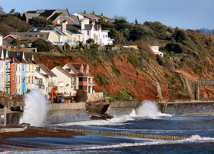
Photo: Smalljim via Wikimedia Commons
Overview
The Floods Directive (FD) 2007/60/EC is the European legislation for managing flood risk from floods of all flood types (fluvial, pluvial, sea water, groundwater, artificial water bearing infrastructure). It has a particular focus on riverine and coastal floods (Art. 2) and regards water flows in the natural entity of river basins (defined in Article 3.1 Water Framework Directive 2000/60/EC). Coastal waters are assigned to these river basin districts as well as are groundwater bodies. The implementation of the FD is streamlined with the Water Framework Directive (WFD) in order to increase the synergies of river basin management and flood risk management measures. As the both Directives are implemented in coordination with each other, the Floods Directive is also indirectly linked to the implementation of the Marine Strategy Framework Directive.
The Floods Directive entered into force in 2007. Its main implementation milestones for the period 2007 – 2015 include the production by Member States of Preliminary Flood Risk Assessments, Hazard and Risk Maps and Flood Risk Management Plans. The FD outlines the goals, methods and implementation schedule that each Member State has to fulfil for each of these milestones. They shall be reviewed on a rolling basis, to take into consideration - among other changing aspects - the impacts of climate change. In the following section, the milestones and Member State implementation (in Risc-Kit case study countries) and reporting are described in more detail.
Implementation
Preliminary Flood Risk Assessments were based on available data and had to be published by the end of 2011. All Member states apart from Portugal complied with the deadline. At the time of writing (2017), all assessments were published. The assessments include (Article 4 of the FD)
- topographic and land use maps, indicating basin and sub-basins borders and coastal areas where existing;
- description of significant historical flood events, describing extension, damages and effects on social, economical and environmental systems; (iii) past events that are expected to be repeated in the future;
- an assessment of potential consequences of future events on socio-economics and environmental issues, in relation to topography and hydro-geomorphology of the basins, water-management structures and natural environment, human activities, long-term human development and climate change affection.
A review of the submitted Preliminary Flood Risk Assessments shows that coastal floods account for 16% of the reported historical flood events, after fluvial (66%) and pluvial (20%) floods. Despite being a coastal country, Sweden did not include sea water floods in its risk assessments. It will rectify this omission in the updated risk assessment in 2018. Germany and the Spanish mainland included all potential flood types in their assessments for all management units. For the Canary Islands, only sea water floods were reported. Among coastal Member States, Germany, Spain, France and parts of the UK (Scotland) provided complete reports that fully complied with Article 4 of the Directive. The delineation of management units in Italy was particularly problematic, in particular for the north-east of the country. Here, the boundaries are not in accordance with the hydrological units. (For more information see Nixon et al. 2015).
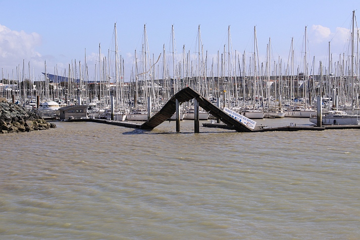
Photo: J.P. Bazard via Wikimedia Commons
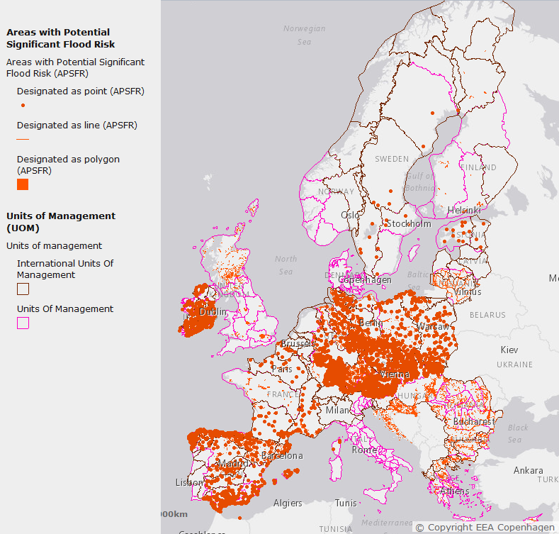
The preliminary flood risk assessment led to the identification of Areas of Potential Significant Flood Risk (APSFR, see Figure 1) for which Flood Hazard and Risk Maps (FHRM) were to be developed by the end of 2013. The maps were required to include floods with low, medium and high probability. If it is considered that in coastal areas adequate protection is in place, only low probability (high magnitude) scenario maps need to be prepared. The maps should be developed:
- based on low, medium and high probability of event occurrence,
- describing potential flood areas, water depths or levels and flow velocities or water flow,
- including information about affected population and economic activities, potential pollution due to in the flood zone located installations and other necessary information (e.g. potentially high content of transported sediments and debris, other significant sources of pollution)
Examples of Member State FHRMs can be found here.
Figure 1: Areas of Potential Significant Flood Risk (APSFR) in EU Member States.Source: EEA (2015): Floods Directive PFRA / APSFR. European Environmental Agency. © Service Copyright EEA Copenhagen Esri, HERE, DeLorme, MapmyIndia, © OpenStreetMap contributors
A review conducted by Nixon (2015), provides an overview of methodologies applied in the preparation of FHRMs. Germany, Spain, France, Italy and the UK created FHRMs specifically for coastal floods, in contrast to Belgium that reported coastal floods in combination with fluvial floods. Bulgaria, Portugal and Sweden did not provide maps for coastal floods at all. They were produced for the medium and low probability scenario (see Table 1, Bulgaria is not included in the assessment). Apart from Belgium and Spain, these countries also published maps for the high probability scenario.
Only five Member States in total – including Belgium, Italy and the UK – reported flow velocities in their hazard maps. Other aspects, like flood extent and water depth/level were reported in all maps. Climate change was only included for few regions or Member States. Scotland considered climate change for all flood types, whereas Germany included climate change impacts in particular for the coastal flooding scenarios. Spain, increased the number of APSFRs identified in the preliminary flood risk assessment due to coastal flooding. Spain like Germany, took existing coastal flood defences into account in its FHRM. Germany reported furthermore, that the risk of failure of those defence structures has been assessed and thus the adequacy of the structures estimated.
Table 1: Summary of coastal flooding scenarios mapped by member states under the floods directive with associated expressions of probabilities
|
|
Low probability |
Low probability |
Medium probability |
Medium probability |
High probability |
High probability |
|
|
Return Period(Years) |
Percentageprobability |
Return Period(Years) |
Percentageprobability |
Return Period(Years) |
Percentageprobability |
BE† |
1000 |
/ |
100 |
/ |
/ |
/ |
BG |
* |
* |
* |
* |
* |
* |
DE |
200 |
/ |
100; 200 |
/ |
20 |
/ |
ES |
500 |
/ |
100 |
/ |
/ |
/ |
FR |
1000 |
/ |
100; 300 |
/ |
10; 30 |
/ |
IT |
300; 500 |
/ |
100 |
/ |
20; 50 |
/ |
PT |
** |
** |
** |
** |
** |
** |
SE |
** |
** |
** |
** |
** |
** |
UK |
1000 |
0.10% |
200 |
0.5%; 1% |
10 |
10% |
LEGENd:
† mapped in combination with fluvial flooding
* No reporting carried out
** No mapping carried out
/ not included in mapping
Flood Risk Management Plans were to be prepared for each river basin district by the end of 2015. These should be developed in accordance with the 2nd River Basin Management Plans under the Water Framework Directive (WFD) and outline the following points:
- establishing objectives for the risk management, focusing on the reduction of potential adverse consequences on social, economic and environmental systems;
- measures have to be defined to achieve the objectives, taking into account aspects such as costs and benefits, floods extensions and infrastructures affection, potential human and natural water retainers, the environmental objectives defined by the WFD (2000/60/EC), soil and water management, spatial planning, land use, ecosystems conservation and sustainability, river and maritime navigation and port infrastructures;
- the plans have to take into account all risk management related aspects: prevention, protection and preparedness, including forecasting and early warning systems based on the river basin features and promoting sustainable activities and resources use;
- Member States shall take into account the principle of solidarity and adopt measures that do not significantly increase flood risk upstream and downstream.
At the time of writing (January 2017), the Flood Risk Management Plans have not been collected to view on the Water Information Service Europe (WISE) portal. However, most of them have been produced and can be viewed on the pages of the national or regional management authorities (See Table 2 below).
Both the European Commission as well as EU-funded research projects have produced a range of guidance documents to help Member States fulfill the reporting requirements set out in the Directive. Some examples include:
- Guidance for Reporting under the Floods Directive (2007/60/EC): Official document within the Common Implementation Strategy that provides guidance for water managers in the elaboration of the three main reporting types under the FD.
- Natural Water Retention Measures: Report within the Common Implementation Strategy that describe the multi-benefits of green infrastructure for the purposes of the FD and WFD.
- River Basin Management in a Changing Climate: Guidance how to include climate variability and change into considerations for flood risk management produced within the Common Implementation Strategy.
- Handbook on Good Practices for Flood Mapping in Europe: The handbook was produced by EXCIMAP, an initiative for knowledge and experience exchange on floods. It is not an official guidance but it represents most of the FD principles.
- Toward more flood resilience: Is a diversification of flood risk management strategies the way forward?: Scientific articles based on the results of the research project STAR-FLOOD.
Table 2: Overview of Flood Risk Management Plans in Risc-Kit case study countries
References
Nixon, S., Horn, J., Hödl-Kreuzbauer, E., ter Harmsel, A., Van Erdeghem, D., Dworak, T. (2015). European Overview Assessment of Member States’ reports on Preliminary Flood Risk Assessment and Identification of Areas of Potentially Significant Flood Risk. http://ec.europa.eu/environment/water/flood_risk/pdf/pfra_reports/EU%20PFRA%20Overview%20Report.pdf
Nixon, S. (2015). EU overview of methodologies used in preparation of Flood Hazard and Flood Risk Maps. http://ec.europa.eu/environment/water/flood_risk/pdf/fhrm_reports/EU%20FHRM%20Overview%20Report.pdf
Hegger, D. L. T., P. P. J. Driessen, M. Wiering, H. F. M. W. Van Rijswick, Z. W. Kundzewicz, P. Matczak, A. Crabbé, G. T. Raadgever, M. H. N. Bakker, S. J. Priest, C. Larrue, and K. Ek. 2016. Toward more flood resilience: Is a diversification of flood risk management strategies the way forward? Ecology and Society 21(4):52. https://doi.org/10.5751/ES-08854-210452
LINKS
EU Floods Policy: http://ec.europa.eu/environment/water/flood_risk/
Guidance for Reporting under the Floods Directive (2007/60/EC) https://circabc.europa.eu/sd/a/acbcd98a-9540-480e-a876-420b7de64eba/Floods%20Reporting%20guidance%20-%20final_with%20revised%20paragraph%204.2.3.pdf
Natural Water Retention Measures https://circabc.europa.eu/sd/a/2457165b-3f12-4935-819a-c40324d22ad3/Policy%20Document%20on%20Natural%20Water%20Retention%20Measures_Final.pdf
River Basin Management in a Changing Climate https://circabc.europa.eu/sd/a/a88369ef-df4d-43b1-8c8c-306ac7c2d6e1/Guidance%20document%20n%2024%20-%20River%20Basin%20Management%20in%20a%20Changing%20Climate_FINAL.pdf
Handbook on Good Practices for Flood Mapping in Europe http://ec.europa.eu/environment/water/flood_risk/flood_atlas/
Member States' examples of Flood Hazard and Flood Risk Maps. Document prepared for the 2015 EU Water Conference http://ec.europa.eu/environment/water/flood_risk/pdf/MS%20examples.pdf