Recent and historic low-frequency, high-impact events have demonstrated the flood risks faced by exposed coastal areas in Europe. Coastal risks are likely to increase in the future. This projected increase in risk along coasts requires a re-evaluation of coastal Disaster Risk Reduction (DRR) strategies and measures.
This part of the RISC-KIT Coastal Management Guide focus on DRR measures that are presented by the display of coastal features. But in order to be able to decide on the best possible measure, they have to be carefully evaluated. A Disaster risk management is a key element of the broader concept of resilience and can be defined as “the application of disaster risk reduction policies and strategies to prevent new disaster risk, reduce existing disaster risk and manage residual risk, contributing to the strengthening of resilience and reduction of disaster losses.” (UNSDIR 2017).
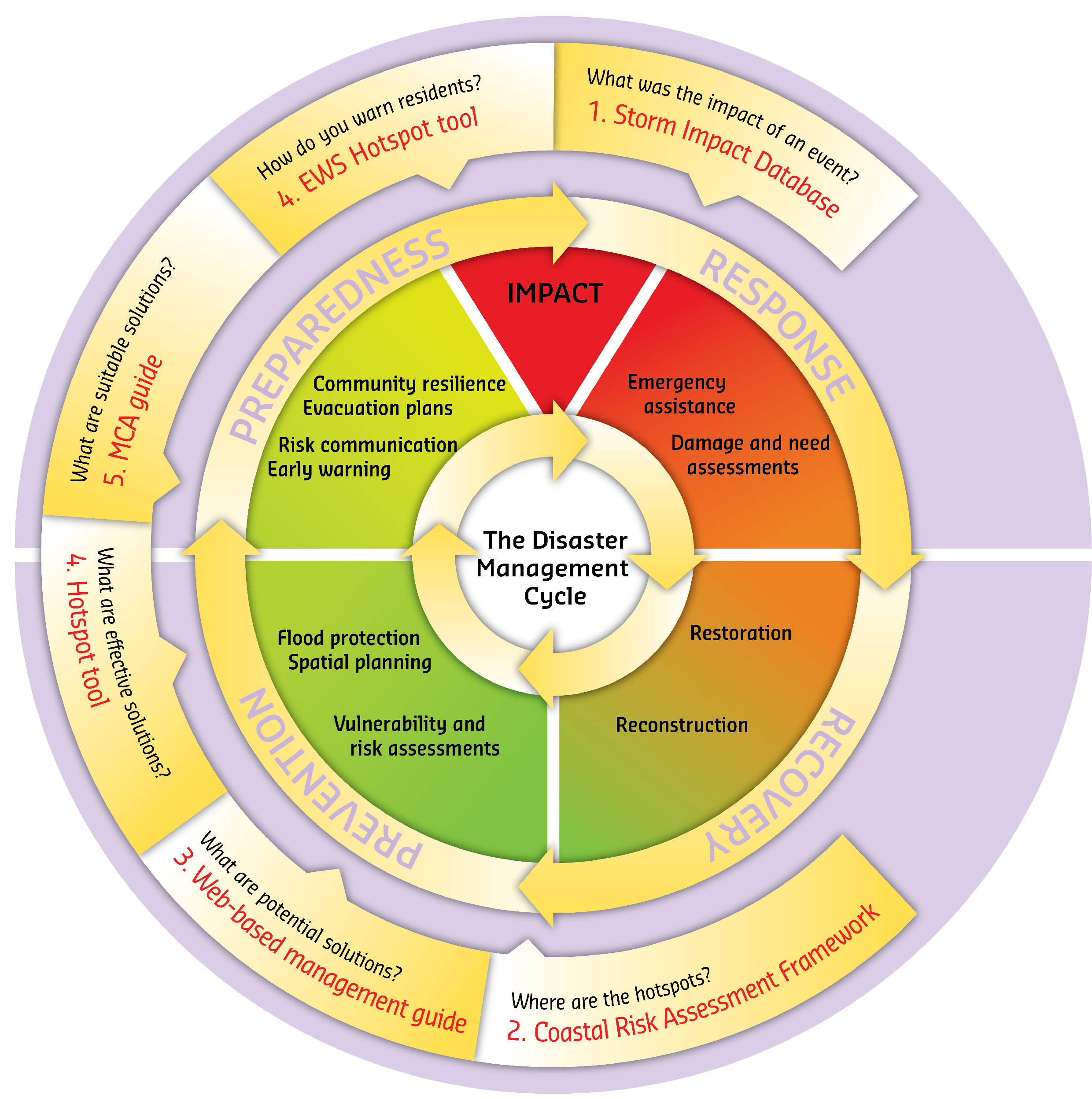
One of the keys to understand coastal risk is to understand the different types of hazards that can occur in coastal and surrounding areas. The Disaster Risk Reduction management cycle illustrates the ongoing process to plan for and reduce the impact of disasters, react during and immediately following a disaster, and take steps to recover after a disaster has occurred. This web-guide focuses on the first part of the cycle: the planning and reducing the impacts by using prevention, mitigation and preparedness measures. The characteristic of the different measures are made more explicit in the differentiation between structural and non-structural measures and different coastal defense strategies.
Hazards
A hazard is “a process, phenomenon or human activity that may cause loss of life, injury or other health impacts, property damage, social and economic disruption or environmental degradation.” (UNISDR 2017) In this webguide, we only refer to hydrometeorological hazards. For UNISDR (2017) these hazards “are of atmospheric, hydrological or oceanographic origin. Examples are tropical cyclones (also known as typhoons and hurricanes); floods, including flash floods; drought; heatwaves and cold spells; and coastal storm surges. Hydrometeorological conditions may also be a factor in other hazards such as landslides, wildland fires, locust plagues, epidemics and in the transport and dispersal of toxic substances and volcanic eruption material.”
For this web-guide, we distinguish between six different types of hazards that can occur in coastal areas due to hydrometeorological hazards:
- Riverine or slow rise floods: Riverine floods or slow rise floods are induced by large scale precipitation or snow melt. In contrast to flash floods, slow rise floods or riverine floods are characterised by relatively slow onset (up to several days), a less severe increase of discharge, increased but still moderate flow velocities and moderate sediment and debris transport
- Flash floods: Flash floods are induced by heavy, often local, precipitation or sudden snow melt or combination of both. It is characterised by fast onset (minutes to hours after a causative event), a heavy multiplication of discharge and high flow velocities and is often accompanied by large sediment and debris flow.
- Estuarine floods: Estuarine floods are induced either by a costal flood whereby flood water is driven into the estuary or the incident of coastal and slow rise flooding meeting in the estuary.
- Coastal floods or storm surges: Coastal floods or storm surges are induced by the combination of temporary sea level rise resulting from extreme meteorological conditions and especially severe in coincidence with high-tide and is characterised by pronounced wave swell
- Urban floods: Urban floods or intra-urban floods are composed of storm water runoff induced by heavy precipitation on urban surfaces, and includes surface flood waves, internal flooding of areas and properties through overloaded sewer systems as well as through backing up of culverted and other water courses. Urban floods are characterised by fast onset, high dynamics of discharge and often uncertain pathways of the flood water.
- Erosion: Erosion is the process of wearing away material from the coastal profile due to imbalance in the supply and export of material from a certain section. It takes place in the form of scouring in the foot of the cliffs or in the foot of the dunes. Coast erosion takes place mainly during strong winds, high waves and high tides and storm surge conditions, and results in coastline retreat.
Disaster Risk Reduction Management Cycle
The disaster risk management cycle (shown below) consists of four phases: Response, Recovery, Prevention and Preparedness. Focus of the RISC-KIT project lays mainly on the pre-disaster phase with tools that address Prevention/Mitigation and Preparedness aspects.

This web-guide can be classified as a prevention tool by helping coastal stakeholders finding the right measures to prevent or mitigate damage or prepare for an effective response to the impact of hazards. Focus of this guide is not the presentation of response and/or recovery measures. Therefore, the presented measures in this guide are classified under prevention, mitigation, and preparedness measures.
Prevention
Prevention is defined by the UNSIDR (2017) as „Activities and measures to avoid existing and new disaster risks.” It “expresses the concept and intention to completely avoid potential adverse impacts of hazardous events. While certain disaster risks cannot be eliminated, prevention aims at reducing vulnerability and exposure in such contexts where, as a result, the risk of disaster is removed. Examples include dams or embankments that eliminate flood risks, land-use regulations that do not permit any settlement in high-risk zones, seismic engineering designs that ensure the survival and function of a critical building in any likely earthquake and immunization against vaccine-preventable diseases. Prevention measures can also be taken during or after a hazardous event or disaster to prevent secondary hazards or their consequences, such as measures to prevent the contamination of water”
Mitigation
The UNSIDR (2017) defines mitigation as “the lessening or minimizing of the adverse impacts of a hazardous event. The adverse impacts of hazards, in particular natural hazards, often cannot be prevented fully, but their scale or severity can be substantially lessened by various strategies and actions. Mitigation measures include engineering techniques and hazard-resistant construction as well as improved environmental and social policies and public awareness. It should be noted that, in climate change policy, “mitigation” is defined differently, and is the term used for the reduction of greenhouse gas emissions that are the source of climate change.”
Preparedness
The knowledge and capacities developed by governments, response and recovery organizations, communities and individuals to effectively anticipate, respond to and recover from the impacts of likely, imminent or current disasters. Preparedness action is carried out within the context of disaster risk management and aims to build the capacities needed to efficiently manage all types of emergencies and achieve orderly transitions from response to sustained recovery. Preparedness is based on a sound analysis of disaster risks and good linkages with early warning systems, and includes such activities as contingency planning, the stockpiling of equipment and supplies, the development of arrangements for coordination, evacuation and public information, and associated training and field exercises. These must be supported by formal institutional, legal and budgetary capacities. The related term “readiness” describes the ability to quickly and appropriately respond when required.” (UNSIDR 2017)
In the ‘Guidance for Reporting under the Floods Directive”, the European Commission (2013) further distinguishes between different types of DRR measures:
- Avoidance: "Measure to prevent the location of new or additional receptors in flood prone areas, such as land use planning policies or regulation" (EC 2013)
- Removal or relocation: "Measure to remove receptors from flood prone areas, or to relocate receptors to areas of lower probability of flooding and/or of lower hazard." (EC 2013)
- Reduction: "Measure to adapt receptors to reduce the adverse consequences in the event of a flood actions on buildings, public networks, etc..." (EC 2013)
- Natural flood, runoff, catchment management: "Measures to reduce the flow into natural or artificial drainage systems, such as overland flow interceptors and / or storage, enhancement of infiltration, etc and including in-channel , floodplain works and the reforestation of banks, that restore natural systems to help slow flow and store water." (EC 2013)
- Water flow regulation: Measures involving physical interventions to regulate flows, such as the construction, modification or removal of water retaining structures (e.g., dams or other on-line storage areas or development of existing flow regulation rules), and which have a significant impact on the hydrological regime." (EC 2013)
- Channel, Coastal and Floodplain Works: "Measures involving physical interventions in freshwater channels, mountain streams, estuaries, coastal waters and flood-prone areas of land, such as the construction, modification or removal of structures or the alteration of channels, sediment dynamics management, dykes, etc." (EC 2013)
- Surface Water Management: "Measures involving physical interventions to reduce surface water flooding, typically, but not exclusively, in an urban environment, such as enhancing artificial drainage capacities or though sustainable drainage systems (SuDS)." (EC 2013)
- Flood Forecasting and Warning: "Measure to establish or enhance a flood forecasting or warning system" (EC 2013)
- Emergency Event, Contingency Planning: "Measure to establish or enhance flood event institutional emergency response planning" (EC 2013)
- Public Awareness and Preparedness: "Measure to establish or enhance the public awareness or preparedness for flood events" (EC 2013)
Structural and non-structural measures
Measures can be distinguished between structural and non-structural measures.
“Structural measures are any physical construction to reduce or avoid possible impacts of hazards, or the application of engineering techniques or technology to achieve hazard resistance and resilience in structures or systems. (…). “Common structural measures for disaster risk reduction include dams, flood levies, ocean wave barriers, earthquake-resistant construction and evacuation shelters. Common non-structural measures include building codes, land-use planning laws and their enforcement, research and assessment, information resources and public awareness programmes. Note that in civil and structural engineering, the term “structural” is used in a more restricted sense to mean just the load-bearing structure, and other parts such as wall cladding and interior fittings are termed “non-structural”. (UNISDR 2017) Furthermore, structural measures can be between an eco-system based approach, grey infrastructural approach (constructed assets built for example of concrete or steel), or a combined approach (grey and green approach).
Non-structural measures are measures not involving physical construction which use knowledge, practice or agreement to reduce disaster risks and impacts, in particular through policies and laws, public awareness raising, training and education. (UNISDR 2017: 28)
Coastal defense strategy
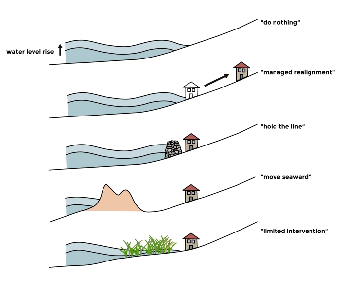
For the structural measures, there are five generic strategies for coastal defense (see below, based on Dronkers et al. 1990).

- Do nothing/deal with the effects: inaction leading to eventual abandonment OR: inaction and allowing natural dynamics
- Managed retreat or realignment: plans for retreat and adopts engineering solutions that recognise natural processes of adjustment, and identifies a new line of defence where to construct new defences
- Hold the line: shoreline protection, whereby seawalls are constructed around the coastlines
- Move seawards: this happens by constructing new defenses seaward the original ones
- Limited intervention: accommodation, by which adjustments are made to be able to cope with inundation, raising coastal land and buildings vertically
