A vulnerability assessment can be used as an informal spatial planning instrument to identify, quantify, and prioritize vulnerabilities in a system. In coastal areas effects of climate change can add additional pressure on these systems. A vulnerability assessment addresses these pressures and analyzes the risks and adaptation capacities to cope with these risks. Results are an important tool in regional and local spatial planning.
The term vulnerability is often used in the context of climate change. The IPCC (2007: 883) defines vulnerability as the “degree to which a system is susceptible to, and unable to cope with, adverse effects of climate change, including climate variability and extremes. Vulnerability is a function of the character, magnitude, and rate of climate change and variation to which a system is exposed, its sensitivity, and its adaptive capacity.” Human pressures (for example due to urbanization, shipping, or tourism activities) but also effects of climate change (sea level rise, storm events) will increase the vulnerability of coastal systems. In the following description focus lies on the coastal vulnerability due to climate change. As mentioned in the definition of the IPCC, a vulnerability assessment consist of three integral parts: the assessment of the exposition (how a coastal region is exposed to certain climate factors like sea level rise or storm floods), the sensitivity (how sensitive the specific coastal system is), and the adaptive capacity (how the coastal system can cope with the changes).
The results of such an assessment can be used in spatial planning processes to find best solution how to cope with the effects of climate change.
There is no formal procedure of how to conduct a vulnerability assessment, but there are reoccurring elements that form a general basis. It necessary to formulate and define the problem and scope of the assessment, define the spatio-temporal aspects, the relevant climate impacts and the potentially impacted sectors, environmental assets and land use patterns. But the assessment should be understood as a process, not as a sole scientific exercise. The German ministry responsibly for spatial planning (BMVBS 2011) has published twelve recommendations for an effective implementation of regional vulnerability analyzes
Success-factors for a regional vulnerability assessment
- Understand vulnerability analysis as a process
- Involve stakeholder from the beginning
- Limit the scope of the assessment early in the process
- Organize the data properly
- Acknowledge (regional) climate models and projections
- Determine the exposure, sensitivity and adaptive capacity
- Conceive comprehensive rules of connectivity
- Keep analyzes only as complex as absolutely necessary
- Visualize results
- Understand results as a basis for discussion
- Inform relevant stakeholder and media
- Develop strategic planning goals
For coastal areas, there are a wide variety of methods that could be integrated into a vulnerability assessment. The objective and the problem to be evaluated are key factors in choosing the most appropriate assessment method. The European Topic Centre on Climate Change Impacts, Vulnerability and Adaptation has published a technical paper on Methods for assessing coastal vulnerability to climate change (Ramieri 2011). The authors analyzed different methods and distinguished:
- indicators and index-based methods,
- GIS-based Decision Support Systems,
- and methods based on dynamic computer models.
Further information on how to apply these different methos (for example what kind of models can be used) can be found here.
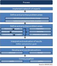
Based on the mentioned success criteria, the BMBVS (2011) has published a possible process of a regional vulnerability assessment. These are based on the active involvement of regional experts from sectoral planning, municipalities and other institutions. They should be asked to bring their experience and knowledge and actively contribute in the implementation of vulnerability evaluation. Moreover, they should be integrated in the formulation of goals and plans how to implement appropriate measures. A schematic sketch of how this procedure could look like, can be seen in the picture gallery.
A vulnerability assessment is a profound supporting tool for dealing with climate change issues in spatial planning processes. They can be an important basis for a cross-sectoral approach to develop adaptation measures.


